omniVUE for Defence & Critical Infrastructure
See the threat. Understand the evidence. Coordinate the response.
Canadian-developed operational intelligence that connects sensors, tracks, video, field systems and approved procedures in one shared environment.
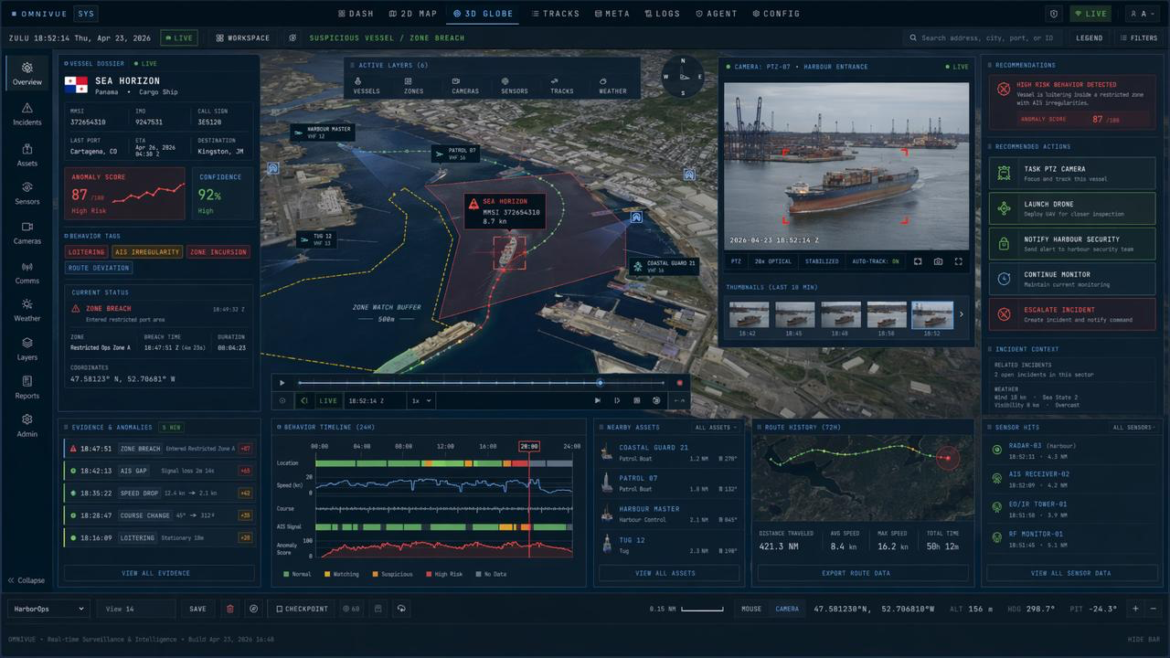
A decision environment—not another data feed
Turn an alert into a defensible operational decision.
Security teams rarely lack information. The harder problem is knowing what matters, validating it quickly and coordinating the next step across people, systems and authorities. omniVUE keeps that complete decision pathway together.
Flagship scenario
Unidentified behaviour. Protected zone. Evidence-led response.
A vessel begins loitering inside a restricted harbour area without a clear operational explanation. omniVUE connects the track, identity, camera evidence and nearby response assets, then presents the next approved steps.
Demonstration environment · AI-assisted · Operator authority retainedSt. John's protected-harbour simulationDetection · Evidence · Coordination · Approval
Detect
A track enters a protected zone or begins behaving outside the expected operating pattern.
Correlate
omniVUE brings identity, movement history, zones, camera evidence and available sensor observations into one incident.
Investigate
Operators can coordinate additional observation through configured cameras, drones, vessels or other field systems.
Understand
AI-assisted analysis explains why the event was prioritized, shows confidence and keeps the supporting evidence visible.
Respond
A configured playbook presents the relevant notifications, escalation path and actions for an authorized person to review.
From observation to accountable action
Capabilities for the complete operational decision loop.
One operating picture
Bring protected areas, assets, tracks, sensor observations, video and conditions into a common 2D or 3D environment.
Anomaly & zone monitoring
Surface route deviations, loitering, restricted-area events and other configured behaviours that require attention.
Multi-source verification
Connect the alert to the available track history, camera view, detections, sensor hits and environmental context.
Targeted reconnaissance
Focus available cameras and connected field assets on closing the information gap around a priority event.
Explainable AI assistance
Summarize the situation, highlight relevant evidence and present the rationale without obscuring uncertainty.
Controlled response workflows
Move incidents through configurable procedures, roles, approval gates and accountable operator decisions.
Simulation & rehearsal
Exercise threat scenarios, data flows and response procedures before they are needed in operations.
Operational record
Preserve evidence, recommendations, approvals and actions for review, learning and after-action reporting.
Built around the operational environment
Make existing systems more useful together.
omniVUE is configured as an integration and decision layer. The deployment model starts with the information, systems and authority structure already in place, then connects the pieces required for the mission.
Integration scope depends on available interfaces, permissions and customer-approved system design.
Detection & tracking
AIS, radar, RF and other available track sources
Visual confirmation
Fixed, PTZ, thermal and other EO/IR cameras
Field systems
Drones, uncrewed systems, patrol assets and mobile teams
Operational context
Zones, weather, facility information and customer data
A proven maritime foundation
The technology changed. The mission did not.
Before omniVUE, Engage developed BridgeVUE—an augmented-reality maritime awareness system created to make sensor information easier to understand in demanding operating environments. The predecessor technology was supported through Canada's Ocean Supercluster and tested with the Royal Canadian Navy through the Innovative Solutions Canada Testing Stream.
Those lessons in sensor integration, small-target awareness and operator-centred visualization helped shape the broader omniVUE platform: a configurable 2D and 3D operational environment with AI-assisted analysis, simulation and governed response workflows.
Read our storyImmersive maritime awareness
A focused predecessor built around the operator's view.
Real-world mission learning
Predecessor technology tested through a federal innovation program.
Operational intelligence
A broader platform connecting awareness, evidence and governed action.
One operating pattern · Multiple protected environments
Designed for sites where uncertainty has consequences.
The protected-harbour scenario makes the capability tangible. The same platform pattern can be configured around other physical sites, data sources, operating zones and response authorities.
Naval harbours & defence facilities
Create a shared security picture around vessel traffic, protected zones, cameras, field assets and incident procedures.
Ports & marine terminals
Connect waterside security, vessel behaviour, visual evidence and coordinated response around critical marine infrastructure.
Offshore & coastal energy
Maintain awareness around remote assets, changing conditions, maritime traffic and defined safety or security zones.
Airports & transport hubs
Apply the same multi-source awareness and governed-response model to complex, high-consequence operating areas.
Remote & Arctic installations
Coordinate sparse data, distributed assets and limited field resources across difficult operating environments.
Emergency & security command
Give partners a common incident context while preserving the roles, authorities and approvals of each organization.
The visuals on this page show configured demonstration and simulation environments. omniVUE supports operator decision-making; deployment scope, integrations and external actions are governed by the customer's authority and approved procedures.
A focused path to a credible pilot
Protect one critical site. Prove one decision pathway.
Start with an existing sensor mix, one priority threat scenario and the people responsible for the response. Configure the complete loop from detection and evidence to approval and review.